From 2012 - Yukon Exposure
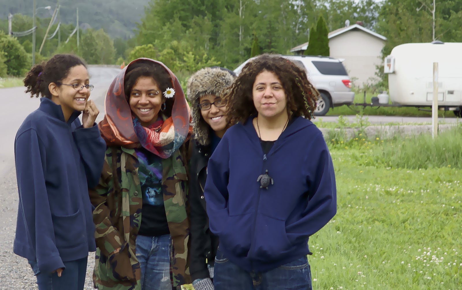
These pictures, and the post below, are from our trip to the Yukon and part of Alaska in 2012. Sarai, Darcy, Abina a/k/a Sunny and Leni accompanied us.

Notes From the Road – Yukon Exposure
It’s a place of contrasts. Saskatoon, SK appears to be prospering – lots
of construction and road work going on.
Someday we’ll have to return when we have more time. Throughout BC and the Yukon, we saw much
evidence of economic hard times – empty storefronts, property for sale or rent,
rundown or vacant houses, towns that appear to have a fraction of their former
population.
Edmonton, AB may be important
industrially, but it is not a city I would ever want to live in or even visit
for an extended period. More factories
and industrial parks than I’ve ever seen anywhere. The air smells bad, but you get used to it
very quickly.
History Repeated. At
Ft. Nelson, BC, we had our first history lesson. At the Heritage Museum we learned about the
gargantuan effort it took to build the AlCan Highway in just nine months back in
1942. It was a war effort, as the US
government at that time believed a land attack from Japan through Alaska was a
real possibility and needed a way to move men and equipment. The highway is a marvel to drive, but it came
at a huge price: the displacement of entire cultures, the First Nation
tribes. Later, at the George Johnston
Museum in Teslin, we heard accounts of people prevented from hunting on the
land that had supported their people for generations, forced into boarding
schools and deprived of their language, and dying in thousands of diseases they
had no ability to fight. After decades
of repression and neglect, the First Nation cultures and languages are now
being preserved and the language is once again being taught in the
schools. People who had no access to
traditional ceremonies when they were young are being given new names and
identities. Their stories are told
through the eyes of a First Nation man who was an accomplished
photographer.
You forget that 100 miles of
mountain driving is not like smooth freeway driving. It takes a lot longer and leaves even the
passengers much more tired. We often did
not make our daily mileage quotas, but made steady progress nonetheless.
Hot Springs and Wild Life. One recreational stop was Liard River Hot
Springs, a BC provincial park. It is an
extremely low-impact facility; there are changing rooms but no water (restrooms
are composting). There are two sections
to the spring, in two different temperatures.
It’s like a hot tub; very relaxing, but not something you can tolerate
for long. The spring is set in an old
growth area of forest, where the air was fragrant and the water steamed
faintly. I kept imagining something out
of “Jurassic Park” would come out of the huge, thick stands of fern. There are small fish that have adapted to the
hot water.
It would have been nice to doze
in the car after the hot spring swim, but between the springs and Whitehorse we
saw more wildlife than we’ve ever seen in all our other trips combined. Black bears, two young grizzlies, countless
sheep, a moose cow, and an entire herd of 40-50 bison. The bears and moose got out of the way
quickly, but not the bison, who plodded calmly alongside the road, kicking up a
haze of dust along the shoulder. Large
males guarded the herd at the front and the back, occasionally standing right
out on the highway. We were as close to
their huge, shaggy heads as the next lane - we could almost feel their hot,
huffing breath and look into their eyes.
They are so old; they have been here since before we came and they will
be here after we are gone, and they know
it. Looking in their ancient eyes gave
me goosebumps.
We stopped at the Toad River Cave
along the way for a snack. Local lore
has it that Toad River is not named after an animal, but named after the fate
of many vehicles in the area . . . towed!
It has a famous collection of hats – just any random hat people give
them is nailed to the walls or ceiling – thousands of them. See, everything out here is done in a big
way.
Tales of the Northern Latitudes. Whitehorse, YT is a pretty town, curving
around the river and surrounded by mountains.
We spent two days there. At the
Beringia Interpretive Center we learned of an entire subcontinent that
scientists believe used to be in this area, then covered by glaciers that later
melted. Skeletons of prehistoric animals
from the period are still being discovered – a mammoth skeleton was found in
Kenosha, WI in 1994. When the glaciers
melted, the resulting rivers, we were told, must have been so big there is no
contemporary equivalent to describe them.
There’s that word again . . .
Next door, the Yukon
Transportation Museum gave yet another view of the gold rush, that of the
miners and those who got them to the Yukon and back, usually empty-handed. But our favorite was the story of a pilot and
passenger who survived 49 days after their plane crashed in the Yukon in 1961,
on little food and with severe injuries.
Nature is no joke out here, even now, in summer. There are signs urging drivers to check their
fuel supply since towns and gas stations, not to mention stores, are scarce.
Small World. At the
Kwalin Dun Cultural Centre we watched the carving of a totem out back of the
building. The totem will be a memorial
to children who were forced into boarding schools in the 40s, 50s and 60s, with
tragic consequences. It is part of a
healing project being carried out in partnership with various tribes and funded
partly with government arts grants.
While we watched the carving of this huge cedar log, we met two unlikely
residents of Whitehorse – Charlie from Jamaica, and his friend, Toussaint, from
Senegal. They had dreadlocks, which
immediately gave them a common ground with LCR.
They met Sarai and she spoke to them in French and in Wolof, which
Toussaint said he had not heard since leaving his homeland.
It’s really true that they have
long days in summer up there. I was not
expecting it, this far south of the Arctic Circle, but it was light far into
the night. At Whitehorse, it was light
as day at 11:30 p.m. Walking through the
campground, I noticed it was awfully quiet – people were in bed or nearly so,
despite the light. We thought it would
be difficult to sleep in such light but it’s not. Your body knows when it needs sleep.
In the evening we drove outside
of town to Miles Canyon. It was a good
place to just hang out in nature, something we’d not had much time for. There are hiking trails and a suspension
bridge, and a small peninsula nearly surrounded by the river.
Traveling with six people in a
trailer designed for four was a challenge.
The younger girls reasonably pointed out that they are no longer little
kids and should not always get the least desirable sleeping spots. They worked out a rotation schedule. For the most part everyone got along well, in
spite of so much togetherness. For most
of the trip it was too cold or buggy to just hang around outside so we were in
the trailer in the evenings. We spent
the time with crafts, games, reading, and sharing a laptop when we had internet
service.
The MacBride Museum in Whitehorse
seems small at first but there are more buildings out back. We were filled to the teeth with local
history by the time we left – miners, Mounties, local society, First Nation
people, animal lore. It was time to head
for Alaska.
Gateway to the Klondike.
We were unprepared for the drive to Whitehorse from Skagway to be so
breathtakingly beautiful. The road threads
through snow-capped mountains and then up and up until you are right in the
middle of the snow caps. Ice fields,
waterfalls, craggy rocks, mist and fog everywhere; but you cannot stop for
photos because it is also peppered with “Avalanche area – do not stop”
signs. I noticed the car got very quiet
when we saw those signs.
Skagway is surrounded by
steamy-looking mountains on three sides.
It is very small – pop. less than 100.
The weather is unique. It mists a
lot and while we were there always looked like rain, but when it did finally
rain the sun would already be out again and it did not last. We had been told that Skagway, crowded with
tourists, is “all about the shopping.”
Apparently people go there to buy diamonds and other jewelry. The girls and I went in search of fresh
salmon and shrimp, which we found sold from a trailer parked on a deck with
tables around it. It was all guaranteed
locally caught and fresh, and though expensive it certainly was delicious. It was cold but not quite too cold to eat
outside. We had to keep our eyes on the
time more than usual, because Alaska has its own time zone. Even my atomic clock was not set for that
many zones so I was constantly subtracting an hour.
The National Park Service owns
many buildings in Skagway and a tour of the park is a walking tour of some of
the buildings, dating from the gold rush days.
I had to hand it to our guide for keeping her cool and concentration - there
were costumed dance hall girls calling out across the street from a “brothel”
that offered tours, while she was trying to give her historical
presentation. Part of the park is in the
mountains, with hiking trails and the remains of a village at the trailhead to
the gold fields, but we did not see much except a few pieces of wood. Park Service employees told us it has all
gone back to nature. That was not clear
from the brochure. It’s a rare case of
something not being as promised in a national park. However, on the drive back we saw an eagle
and were able to get some photos.
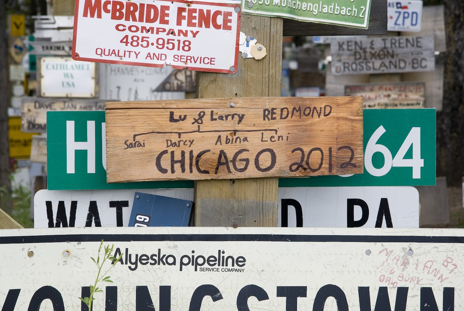
Passing through Watson Lake the
second time, on our way back north, we affixed a sign in the Signpost Forest,
started by a homesick worker on the AlCan highway who put up a sign with the
name of his hometown, Danville, IL.
There are thousands of signs pilfered and homemade, with names of people
and towns from all over the world. The
visitors’ center provides hammer, nails and a ladder if needed. The visitors’ center gave the count as
71,125. Now there is one more.
Another Kind of Wildlife.
On the way to the Salmon Glacier area, we stayed at Bell II, which is
really a resort catering to heliskiiers, with a few RV hookups. We had been warned about the mosquitos in the
area, but did not really think about it much – after all, we were from the
Midwest; we knew from mosquitos. We did
wonder why the beautiful Jacuzzi at Bell II was deserted, but we soon found
out. BC mosquitos are large, fast and
persistent. When they started coming
into the trailer, it felt like a siege.
The girls ran around plugging cracks with paper towels and duct-taping
the openings around vents, but still they came in. I caught one squeezing through a crack –
never knew mosquitos did that. When we
pulled back the curtains we could see them on the window on the outside by the
dozens, and we could hear them on the vent screens. Did I mention they are also noisy? Eventually we did get some sleep but in the
morning they started coming in again.
Defeated, we unhooked and left without breakfast or even rudimentary
hygiene. Only something this serious
could get us going at 7:15 a.m.!
We drove to Stewart, BC, and the
woman at the visitors’ centre graciously allowed us use of the restrooms for
grooming, saying she had worked at Bell II and was aware of the mosquitos. This area, she explained, had gotten a lot of
rain recently, unlike the rest of western Canada which is in a drought. We said what we really needed was
breakfast. She directed us to the
Glacier Inn in Hyder, AK.
When you cross the border into
Alaska at Hyder, the pavement drops off all at once, and from then on it was
mostly unpaved roads for the rest of the day.
Hyder was disparagingly referred to by one Canadian we met as “a
draft-dodger town” from the Vietnam war days, being on the border in thickly
wooded mountainous country, but today it is almost a ghost town. However, the Glacier Inn was open and served
us eggs, fresh-baked bread, oatmeal and fresh fruit, so good it almost made up
for having to flee for our lives. The
Inn has dollar bills plastered all over the walls and pillars and supplemental
boards. People write their names and the
date and a message. Sort of like the
Signpost Forest, only with money, American and Canadian bills, going back for
years, thousands of them . . . and now, one more.
Glaciers and the Bear Man. We had left the trailer in Stewart on the
advice of the visitors’ center guide, and it turned out to be a good decision. The road to the Salmon Glacier was some of
the most bone-jarring we’ve driven – washboarding, potholes, no pavement for
miles. After jouncing and jerking for some
time, we found a truck that seemed to know the way, hanging slightly to the
left to avoid the worst of the potholes, and followed it. It turned out to be involved in the road
construction and we nearly followed it into a “no public access” area. However, the reward at the end was incredible
views of live glaciers, the Salmon and the smaller Bear, seen from above. The ice appears blue in places and there are
small caves, where water flows out from underneath, at the “toe,” the area of a
glacier that reaches toward the river.
Though scientists believe the glaciers have been shrinking for the past
15,000 years, they still look huge, majestic, unstoppable.
Far up the mountain, there is a
rest stop and a man who lives there all summer – Keith Scott, a retired teacher
of nature and ecology, who calls himself the Bear Man. He sells his own photos, DVDs and books about
the glaciers and the bears in the area.
He has an SUV, a bike, and a tent.
I did not see a fire but I did see an old car bucket seat positioned to
look out over the mountain, out of the worst of the wind at the back of the
outhouse. When asked how he survives
out there, even in summer, he assured us the cold is not a problem, as the
temperature rarely drops below freezing (!).
He advised us to go a bit farther, past a “Road Closed” sign, to get out
of the fog and get a better view of the glacier from above. Truly, that was the only time we disobeyed a
sign. The fog was indeed lessened past
the sign but we thought the view was not as spectacular as what we’d already
seen farther down the mountain. On our
way down, we found that being on the returning side of the road now made us
experts, and we fielded questions about the road and whether it was worth the
trouble.
Spending the night in Kitswanga,
we were given pins and tiny Canadian flags, because the following day was
Dominion Day. A First Nation man at our
campground explained that native tribes celebrate the day, also called
Aboriginal Day, along with white Canadians, because we are all brother
nations.
For some reason we did not see
any Dominion Day celebrations. The small
towns we passed seemed almost vacant – perhaps the inhabitants were at larger
towns. However, we did see quite a few
native totems in several sites in the area.
We also visited a recreated village called ‘Ksan. There are various buildings with artifacts,
some genuine and some newly created, placed as they might have been when
indigenous tribes lived here. The park
is tightly controlled: no photos allowed in the buildings, but the guides are
knowledgeable and audio-visual presentations are used inside the buildings in
lieu of written descriptions. We bought
souvenirs at the gift shop which had many native and locally made items as well
as the ubiquitous t-shirts.
The night before we saw Mt.
Robson, we were once again bothered by monster mosquitos and left early. We stopped there for breakfast and noticed
that this area, which heads south through Jasper and Banff National Parks, is a
magnet for a variety of races, age groups, and types of people, dressed in everything
from biker leather to Amish suspenders, with many accents and languages - a true United Nations. The mountain itself was shrouded in fog.
Chasing Waterfalls. We had intended to drive south through the
Jasper/Banff area in a few hours, but we had no idea what we were in for. The two parks are some of the most wonderful
mountains we have ever seen, beautiful views around every bend, waterfalls, and
glaciers. Instead of driving through we
had to pull over constantly to walk out for a better view and a photo. One of the most spectacular waterfalls was
not even marked and did not seem to be on the map. We rounded a bend and at first thought there
had been an accident, there were so many cars pulled over haphazardly and
people standing around, almost in the road.
We got quite muddy because it was rainy that day. Yet another fact we did not know - part of
the drive is a temperate rain forest, rare for that latitude.
We hiked out to the Athabasca
glacier,6,500 feet up. You could really
feel the altitude. Some people were
prepared with parkas and hoods, but we also saw shorts and flip-flops. It always amazed me that the air temperature
never seemed to drop below 40 F even when there was ice and snow. At the glacier, there were warning signs
forbidding walking out on the ice.
Apparently, the ice can look solid but open into deep crevasses without
warning, and the last few rescues were unsuccessful, with the victims dying of
hypothermia before they could be pulled out.
We did see a party far out on the glacier and could only assume they had
some kind of special permit.
Eventually we decided to stop
looking and keep driving. We decided
this several times. By the end of the
day, we were wet, dirty, stiff and sore, but it was one of the best days of the
trip.
Besides the usual wildlife
warnings (eventually just “Watch for wildlife on highway,” with no reference to
species), there were several viaducts on Canada Hwy 16, which we learned were
land bridges for the animals. Deer,
bison and other animals can migrate freely without crossing traffic. Infrared cameras prove they are indeed
used. They are beautifully landscaped
with grass and small trees, and barely visible fences.
Windy City. We were
now on the edge of the Rockies, and stopped at a town with several
campgrounds. Fearful again of mosquitos,
we chose the most open. It was almost
vacant. It was also the windiest spot
we’ve ever camped in. The howl was
unbelievable, the trailer shook, you had to hang onto your stuff if you went
outside. A trip to the bathroom felt
like an endurance trek. LCR needed to
fill the trailer water tank, and the wind was so raw that he actually waited
inside the car with the hose hooked up.
There were no bugs so the girls were happy. Well, of course; the cracks the bugs had come
through the previous night were now conduits for the roaring wind. I had visions of the trailer rolling over and
over, or split by a piece of some roof or other driven by the wind, or a window
popping out with no way to patch the hole.
The wind was somewhat lessened by morning. We learned in the next town, Swift Current,
that Saskatchewan is known for its wind and that its inhabitants claim the wind
pushes weather fronts through so fast, they may have to use their heat and AC
in the same day. We bought an electric
mosquito zapper, having seen one used by a campground owner a few towns back –
looks like a small badminton racket - but wouldn’t you know, that night we had
barely enough mosquitos to ascertain that the thing does work. The quiet that night was wonderful - no
insects, little wind.
One thing we had not yet done on
this trip was visit an art museum, so in Moose Jaw, we went to the local
history and art museum. Though very
small, the museum has some interesting local art and history, including a
surprisingly long and vibrant history of Chinese immigration. One thing that they apparently do not know is
the origin of the name Moose Jaw.
Past Moose Jaw, we stayed at a
campground that definitely got the prize for the darkest. A small boy came by our campsite lost and
crying. Hoping LCR could get hooked up
before nightfall, I took him back to the office to figure out where he was
supposed to be, and eventually back to his family’s trailer. I just barely made it back to the trailer
before dark. Thinking I would empty some
recycling and use the bathroom, I went outside, but it was so completely dark I
could barely find the car – even though it was still hooked to the trailer. I could also hear animals rustling in the
underbrush. Though I thought it was
probably only a raccoon or fox, I stayed in the trailer.
It was time to move on and get
back to the States. We had to give
Winnipeg a pass; it will be there another time.
In MN we stayed with the Petries, as we had on the way out. It was so great to see them twice on this
trip. Abina stayed with Caylah as she
had on the way out. June and I had an
impromptu knitting clinic, and we saw a bit of the Tour de France, feeling like
we were getting reconnected to our homeland and the rest of the world in
general. It was 88 in MN, much warmer
than we’d been for weeks but apparently not as warm as it was in MN, WI and IL
while we were gone.
Gas prices: not good anywhere;
$3.42 in Madison; higher everywhere else.
Gas is sold by the liter in Canada and some places offer only full
service. The multiplier is 3.78 liters
per gallon. The monetary exchange rate
was nearly even.
Signage.
Canadians appear to love acronyms
as much as Americans:
R.A.P.P. (Report All Poachers and Polluters)
This Area Patrolled by COPS (Citizens
on Patrol)
Sign in bar window: Free beer tomorrow.
Road sign: “Distracted driving law in effect.”
Posted at the entrance to Liard
River Hot Springs: “The BC government is
conducting a Bear Encounter Avoidance Project.
You may occasionally hear loud noisemakers.”
On Canada Hwy 16: “Speed limit not to exceed 50 kmh when
children on highway.”
And the winner, as the sign most
likely to make everyone wake up and take notice, posted on the road between
Vanderhoof and McBride: “High Moose
Collision Area.”
- Lu & Co.


Comments
Post a Comment